

Eastern Lake Erie Buoys
The Great Lakes Center at Buffalo State University operates two weather/data buoys: one outside of Buffalo and the other off the coast of Dunkirk, NY. These buoys are part of the Great Lakes Observing System (GLOS) and provide real-time wave, weather, and water conditions to a diverse set of users.
Contact: buoy@buffalostate.edu
Ways to Support
These buoys are community resources that benefit from stakeholder involvement and investment. Your support helps ensure that these resources are available for many years to come. There are a number of ways you can support the buoy program.
Provide user feedback
Tell us your use case. How does the real-time data help you? What parameters do you use the most? Do you use it for work, recreation, teaching, etc.?
Keep an eye out
As you use this data, please let us know if something is not working or if you observe any readings that seem off or incorrect. Please provide specifics, such as parameter, date, and time so we can troubleshoot.
If you happen to be out on the water, feel free to look at the buoy, but please do not touch it. The only vessels that should be making contact with the buoy will have a state logo on the hull. If you see anything that looks awry or any unauthorized activity at the buoy, please contact the Great Lakes Center and if necessary, the Coast Guard.
Make a donation
The presence of these buoys on the water requires a substantial amount of planning, time, personnel, vessels, equipment, and funds. To help these buoys weather all storms, please consider making a donation.
Get involved
Spread the word and share this resource with anybody you think could use it. Reach out if you have questions or need assistance utilizing the Seagull platform or understanding the data. We occasionally visit organizations and classrooms at their request to provide informative talks. If you would like to schedule a visit, please contact us.
Thanks to our Major Financial Supporters
Meet the Buoys
Buffalo Buoy
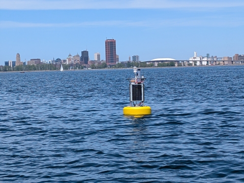
Recognizing the need for real-time data and the many benefits it would bring to the Buffalo waterfront, we sought funding for a new weather/data buoy. In Fall 2025, the Niagara River Greenway Ecological Standing Committee approved funding from the New York Power Authority for the purchase and initial operation of this new remote sensing system. The buoy was purchased in early 2026 and its maiden deployment was May 26th.
The Buffalo Buoy is a NexSens CB-650 data buoy located 2 nautical miles SSW of Buffalo, New York, in the eastern basin of Lake Erie in approximately 40 feet of water. The above-water sensor array includes a webcam and weather station measuring air temperature, windspeed/direction, solar radiation, relative humidity and atmospheric pressure. In addition, a wave sensor mounted just above the waterline measures wave height, direction, and period. Just below the water’s surface a YSI multiparameter instrument measures chlorophyl, turbidity, dissolved oxygen, conductivity, and temperature. Down deeper, a thermistor string is suspended in the water column measuring temperature at intervals of 6.6 ft (2 m).
Dunkirk Buoy
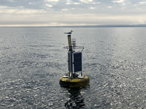
We first deployed this buoy in 2011. Over the years, the buoy has changed with advances in remote sensing technology, from using a smaller buoy body for easier deployment to upgraded sensors that are better able to measure environmental conditions. One thing that hasn’t changed is our commitment to consistent deployment and reliable data collection. Our ability to run the buoy all these years wouldn’t be possible if it wasn’t for the support from our longstanding partners, GLOS and the NYSDEC Lake Erie Fisheries Unit.
The Dunkirk Buoy is a NexSens CB-650 data buoy located 6 nautical miles NW of Dunkirk, New York, in the eastern basin of Lake Erie, in approximately 100 feet of water. The above-water sensor array includes a weather station measuring air temperature, windspeed/direction, solar radiation, relative humidity, and atmospheric pressure. In addition, a wave sensor mounted just above the waterline measures wave height, direction, and period. Below the surface of the water, a thermistor string is suspended with temperature nodes every 6.6 ft (2 m) down to 79 ft (24 m). At 82 ft (2 m), a YSI multiparameter instrument measures dissolved oxygen, temperature, and conductivity.
How the Data is Used
The real-time data from these buoys has very practical applications for people heading out onto the water. Common uses include wave height for safety, water temperature profile for angling, and windspeed/direction for sailing. In addition, this data is used by researchers and natural resource managers to study a variety of ecological and meteorological topics. Various organizations also incorporate information from this buoy into their models. All these measurements can be used to shed light on large scale lake dynamics such as stratification, seiche events, productivity, and seasonal changes.
Contact Us
Email: buoy@buffalostate.edu
Phone: (716) 878-5625
Reach out to Brian Haas or Ben Szczygiel for questions or assistance.