
Written by Dr. Tao Tang, GLC Affiliate
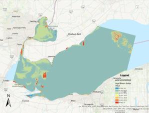
Dr. Tao Tang of the Geosciences Department spent most of his summertime in 2024 conducting research applying Landsat remote sensing data to identify areas and digitally map algal blooms in Western Lake Erie during the last ten years (2013 to 2023).
The Landsat program was established by US National Aeronautics and Space Administration (NASA) in 1972. Since then, a series of Landsat Earth observation satellites have been launched, from Landsat 1 to Landsat 9 today. It is the first scientific Earth surface observation system humans ever built. Currently, we have both Landsat 8 and Landsat 9 in space orbiting the Earth to collect Earth observation data every day. The US Geological Survey (USGS) operates the Earth Resources Observation and Science (EROS) Center that oversees downloading, archiving, and disseminating both current and historical data of satellite images.
According to Dr. Tang, “This is a treasure box for the data of big pictures to study the global environmental change in general and environmental change in the Great Lakes region in particular.” Most of the historical treasures of Landsat satellite images in the Great Lakes region have not been explored scientifically yet. Dr. Tang’s current research is to formulate a mapping index model, analyze, and present the spatial and temporal distributions of algal blooms in Western Lake Erie from 2013 to 2023. A total of 59 Landsat satellite images were used for this research.
Image caption: Algal bloom distribution in western Lake Erie derived from the satellite imagery sampling data on 9/4/2023.
Some content on this page is saved in PDF format. To view these files, download Adobe Acrobat Reader free. If you are having trouble reading a document, request an accessible copy of the PDF or Word Document.
