
written by graduate student Kylie Wirebach
Since compiling a list of Lake Erie tributaries historically used by lake sturgeon (Acipenser fulvescens), Master’s student Kylie Wirebach has begun work on a multiple-scale, multiple-criteria habitat suitability analysis for her thesis work. This project, funded by the U.S. Fish and Wildlife Service, has the goal of quantifying and summarizing the current suitability of historically used watersheds for the potential reintroduction of lake sturgeon, a majorly extirpated species of the Great Lakes.
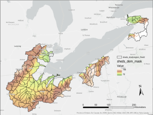
Using habitat suitability analysis is an efficient and effective way to look at and study landscape conditions without having to physically travel to the field. For tributaries all across the U.S. side of Lake Erie, Kylie has collected spatial data to represent the habitat needs of lake sturgeon across multiple life stages, as well as multiple spatial scales. At the watershed level, several data surrogates will be used: landscape slope to represent stream flow stability, watershed forest cover to represent stream temperature, subwatershed area to represent mainstem stream depth, and developed land cover to represent stream substrate embeddedness, among others. At the smaller scale, the stream reach level, Kylie will adapt spatial data used in the USGS Great Lakes Regional Aquatic Gap Analysis project (McKenna et al., 2014): coarse surficial geology to represent substrate size class, mean July water temperature for breeding-period temperature, and stream order to represent flow stability, among others. These data will be classified on a common scale showing high suitability to low suitability for lake sturgeon, then multiplied by mathematical weights based on relative importance to lake sturgeon success, and finally combined to create a composite map showing areas of high to low habitat suitability at multiple scales. These spatial scales will be compared as a means of validating the analysis model, with the benefit of creating a detailed summary of landscape and stream-level conditions for resource managers and conservation groups. In addition, since multiple watersheds are being assessed, they will be compared to one another to identify priority locales for reintroduction and restoration.
Kylie presented her progress on this thesis project at the Annual Meeting of the American Fisheries Society on November 8, 2021, in Baltimore, Maryland.
Image caption: A rough working map showing USGS elevation data across the watersheds of interest; these data are used to derive a slope layer, which will represent flow stability, an important habitat parameter for Lake Sturgeon.
Some content on this page is saved in PDF format. To view these files, download Adobe Acrobat Reader free. If you are having trouble reading a document, request an accessible copy of the PDF or Word Document.
